

Bozeman Mountain Ranges
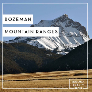
Bozeman is encircled by several iconic mountain ranges. These mountain ranges combined with the large amount of public land provide numerous recreation opportunities for outdoor enthusiasts. Primary Bozeman mountain ranges include the Bridger Range, Gallatin Range, Madison Range, Spanish Peaks, Beartooth Mountains, Crazy Mountains, and Tobacco Root Mountains.
 Bridger Mountain Range – The Bridger Range lies to the northeast of Bozeman and is part of the Gallatin National Forest. The Bridger Mountain Range hosts Bozeman’s hometown ski hill (Bridger Bowl) and a varied collection of nearby trails that are great for an afternoon hike. Elk, deer and mountain goat can often be seen on the western side of the ridge where open meadows provide good foraging and the forested hillsides good cover. Bridger Canyon is famous for the yearly raptor migration. Each autumn, usually in the first two weeks of October, you can view these magnificent birds of prey on their migration south. Over 200 Golden Eagles may be observed in a single day! The tallest peak in the range is Sacagawea Peak (9665 ft/2,946 m) followed by Hardscrabble Peak (9575 ft/2918 m), Saddle Peak (9162 ft/2793 m), Ross Peak (9004 ft/2744 m), Mount Baldy (8914 ft/2717 m), and Bridger Peak (8635 ft/2632 m).
Gallatin Range – The Gallatin Range likes to the south of Bozeman. It includes more than 10 mountains over 10,000 feet (3,000 m). The southernmost peaks of the Gallatin Mountain Range are in the northwestern section of Yellowstone National Park, however the majority of the range is in Gallatin National Forest. The Yellowstone River flows north on the eastern flank of the range. The range is an integral part of the Greater Yellowstone Ecosystem and has grizzly bears, wolves and other threatened and endangered species also found in Yellowstone National Park. The highest peak in the range is Electric Peak at 10,969 feet (3,343 m).
Madison Range – The Madison Range lies southwest of Bozeman and is the westernmost section of what is collectively referred to as the Greater Yellowstone Ecosystem. Most of the range lies within Beaverhead-Deerlodge and Gallatin National Forests. A small portion of the range has been further protected with the creation of the Lee Metcalf Wilderness. The range extends 80 miles (130 km) from West Yellowstone, Montana to Bozeman, Montana and is flanked by the Madison River on the west and the Gallatin River to the east.
Spanish Peaks – The Spanish Peaks lie south of Bozeman and are a sub-range of the much larger Madison Range. Gallatin Peak, el. 11,015 ft., is the highest peak in the group.
Absaroka Range – The Absaroka Range lies to the southeast of Bozeman, just south of Livingston, Montana. The range stretches about 150 miles (240 km) across the Montana-Wyoming border, and 75 miles at its widest, forming the eastern boundary of Yellowstone National Park along Paradise Valley (Montana), and the western side of the Bighorn Basin. The range borders the Beartooth Mountains to the north and the Wind River Range to the south. The northern edge of the range rests along I-90 and Livingston, Montana. The highest peak in the range is Francs Peak, located in Wyoming at 13,153 ft (4,009 m). There are 46 other peaks over 12,000 ft (3,700 m).
Beartooth Mountains – The Beartooth Mountains are located in south central Montana and northwest Wyoming, U.S. and are part of the 944,000 acres (3,820 km2) Absaroka-Beartooth Wilderness, within Custer, Gallatin and Shoshone National Forests. The mountains are just northeast of Yellowstone National Park and are part of the Greater Yellowstone Ecosystem. Huge expansive plateaus are found at altitudes in excess of 10,000 ft (3,000 m) with over 25 peaks exceeding 12,000 ft (3,700 m). The mountains have over 300 pristine lakes and some waterfalls in excess of 300 feet (91 m). Approximately 25 small glaciers exist in the Beartooths with Grasshopper Glacier being one of the more distinctive. The Beartooths are the location of Granite Peak, which at 12,807 feet (3,904 m) is the highest point in the state of Montana.
Crazy Mountains – The Crazy Mountains(often called the Crazies) lie to the north east of Bozeman. They are east of the Bridger Mountain Range, north of Livingston, Montana. The Crazy Mountains span a distance of 40 miles (64 km). The highest point is Crazy Peak at 11,214 ft (3,418 m).
Tobacco Root Mountains – The Tobacco Root Mountains lie southwest of Bozeman, between the Jefferson and Madison Rivers. The highest peak is Hollowtop at 10,604 feet (3,232 m). The range contains 43 peaks rising to elevations greater than 10,000 feet (3048 m).
Bridger Mountain Range – The Bridger Range lies to the northeast of Bozeman and is part of the Gallatin National Forest. The Bridger Mountain Range hosts Bozeman’s hometown ski hill (Bridger Bowl) and a varied collection of nearby trails that are great for an afternoon hike. Elk, deer and mountain goat can often be seen on the western side of the ridge where open meadows provide good foraging and the forested hillsides good cover. Bridger Canyon is famous for the yearly raptor migration. Each autumn, usually in the first two weeks of October, you can view these magnificent birds of prey on their migration south. Over 200 Golden Eagles may be observed in a single day! The tallest peak in the range is Sacagawea Peak (9665 ft/2,946 m) followed by Hardscrabble Peak (9575 ft/2918 m), Saddle Peak (9162 ft/2793 m), Ross Peak (9004 ft/2744 m), Mount Baldy (8914 ft/2717 m), and Bridger Peak (8635 ft/2632 m).
Gallatin Range – The Gallatin Range likes to the south of Bozeman. It includes more than 10 mountains over 10,000 feet (3,000 m). The southernmost peaks of the Gallatin Mountain Range are in the northwestern section of Yellowstone National Park, however the majority of the range is in Gallatin National Forest. The Yellowstone River flows north on the eastern flank of the range. The range is an integral part of the Greater Yellowstone Ecosystem and has grizzly bears, wolves and other threatened and endangered species also found in Yellowstone National Park. The highest peak in the range is Electric Peak at 10,969 feet (3,343 m).
Madison Range – The Madison Range lies southwest of Bozeman and is the westernmost section of what is collectively referred to as the Greater Yellowstone Ecosystem. Most of the range lies within Beaverhead-Deerlodge and Gallatin National Forests. A small portion of the range has been further protected with the creation of the Lee Metcalf Wilderness. The range extends 80 miles (130 km) from West Yellowstone, Montana to Bozeman, Montana and is flanked by the Madison River on the west and the Gallatin River to the east.
Spanish Peaks – The Spanish Peaks lie south of Bozeman and are a sub-range of the much larger Madison Range. Gallatin Peak, el. 11,015 ft., is the highest peak in the group.
Absaroka Range – The Absaroka Range lies to the southeast of Bozeman, just south of Livingston, Montana. The range stretches about 150 miles (240 km) across the Montana-Wyoming border, and 75 miles at its widest, forming the eastern boundary of Yellowstone National Park along Paradise Valley (Montana), and the western side of the Bighorn Basin. The range borders the Beartooth Mountains to the north and the Wind River Range to the south. The northern edge of the range rests along I-90 and Livingston, Montana. The highest peak in the range is Francs Peak, located in Wyoming at 13,153 ft (4,009 m). There are 46 other peaks over 12,000 ft (3,700 m).
Beartooth Mountains – The Beartooth Mountains are located in south central Montana and northwest Wyoming, U.S. and are part of the 944,000 acres (3,820 km2) Absaroka-Beartooth Wilderness, within Custer, Gallatin and Shoshone National Forests. The mountains are just northeast of Yellowstone National Park and are part of the Greater Yellowstone Ecosystem. Huge expansive plateaus are found at altitudes in excess of 10,000 ft (3,000 m) with over 25 peaks exceeding 12,000 ft (3,700 m). The mountains have over 300 pristine lakes and some waterfalls in excess of 300 feet (91 m). Approximately 25 small glaciers exist in the Beartooths with Grasshopper Glacier being one of the more distinctive. The Beartooths are the location of Granite Peak, which at 12,807 feet (3,904 m) is the highest point in the state of Montana.
Crazy Mountains – The Crazy Mountains(often called the Crazies) lie to the north east of Bozeman. They are east of the Bridger Mountain Range, north of Livingston, Montana. The Crazy Mountains span a distance of 40 miles (64 km). The highest point is Crazy Peak at 11,214 ft (3,418 m).
Tobacco Root Mountains – The Tobacco Root Mountains lie southwest of Bozeman, between the Jefferson and Madison Rivers. The highest peak is Hollowtop at 10,604 feet (3,232 m). The range contains 43 peaks rising to elevations greater than 10,000 feet (3048 m).
Category : Bozeman Information , Lifestyle